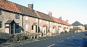
Papplewick conservation area
 The centre of the village, the grounds of Papplewick Hall and the Church of St James, have been designated as a conservation area. This means that there are restrictions on development. They are in place to help to conserve the character of the village centre.
These 18th century cottages can be seen on Main Street, in the conservation area. Like many of the buildings on Main Street, they are built of Magnesian Limestone, with pan-tiled roofs
The following buildings in the parish are ‘listed’.
| Grade I | Papplewick Hall |
| Church of St James | |
| Grade 11 | Engine House / Boiler House and workshop at Papplewick Pumping Station |
| Chetwynd House and Boundary Wall, off Blidworth Waye | |
| Stable range at Papplewick Hall | |
| Walled kitchen garden 100 metres north of Papplewick Hall | |
| Top Farmhouse and adjoining stables, Blidworth Waye | |
| Barn and stable at Top Farmhouse, Blidworth Waye | |
| Gate piers and boundary wall, Church of St. James, | |
| 2 headstones 8 metres south-east of south porch, Church of St. James, | |
| Chest tomb 8 metres south of south porch, Church of St. James | |
| 3 headstones 10 metres south of Tower, Church of St. James | |
| Vincent Plantation Obelisk 20 metres north-west of Vincent Lodge, Forest Lane | |
| The Griffins Head, Forest Lane | |
| No 1 and The Barn, Linby Lane | |
| Boiler house chimney at Papplewick Pumping Station | |
| Smithy, stable and cartshed at Papplewick Pumping Station | |
| Cooling pond at Papplewick Pumping Station | |
| Deputy’s house at Papplewick Pumping Station | |
| Superintendent’s house at Papplewick Pumping Station | |
| Boundary wall and gates at Papplewick Pumping Station | |
| Numbers 9a, 9b, 11, 15, 17, 19, 2l, 23, and 25 Main Street | |
| 49 Pembroke Cottage, 51 and 53 Main Street | |
| The Old Post Office, 55 Main Street | |
| Morton’s Farmhouse, 57 Main Street | |
| Stable and garage to south of Morton’s Farm, Main Street | |
| Papplewick Lodge and adjoining stables, Main Street | |
| Sundial 16 metres north of Papplewick Lodge, Main Street | |
| Numbers 67, 69, 71, 73 Main Street | |
| Howe Plantation Obelisk, 70 metres north-east of Woodland Grange, Mansfield Road | |
| Boundary stone 500 yards west of Mansfield Road | |
| Boundary stone 30 metres north of Howe Plantation obelisk, Mansfield Road | |
| Boundary stone north of Papplewick Pumping Station, Longdale Lane, | |
| Boundary stone at SK 58357 52201 | |
| Boundary stone north of Papplewick Pumping Station, Longdale Lane, at SK 57454 52320 | |
| Boundary stone at the entrance to Newstead Grange at SK 55276 52573. |


